Cydonia Quest C Testing the Arcology Model
c The Fort Formation
The Fort marks the eastern side of the "City" and is one of the most enigmatic of the Cydonia formations. Its location on a 1976 Viking context image can be seen by clicking on this "stargate"µµµ.
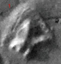
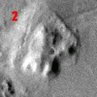
General description. In the 1976 Viking images the "Fort" had some of the most artificial looking characteristics of the Cydonia formations. Both the image taken when the Sun was at a 10 degree angle above the western horizon and also the image taken with the Sun at 30 degrees, revealed a striking triangular arrangement of high "walls" on the Fort's eastern side. This can be seen in Dr. Mark J. Carlotto's image enhancement (# 1) of the Fort with the 10 degree Sun angle. Within the walls there seemed to be a geometrically shaped interior "courtyard" that made the outer walls look like the ramparts of a Fort. However, the image (#2) taken with a 30 degree Sun angle revealed that this "courtyard" probably held few secrets. Despite this the overall effect was still rather architectural and it was natural to speculate that the Fort was an unfinished arcology or one that had collapsed into its hollow interior.
The western side of the Fort formation is more natural looking in the Viking images and consists of a high ridge that overlooks the Fort's "courtyard" and "ramparts" to the West. In the 10 degree Sun angle image there is an oval shaped depression along the Fort's western flank that is an obvious candidate as a subsidence feature. There is also a groove that curves around the northern end of the Fort and back down its western flank.
C
C Possible subsidence features in the Fort
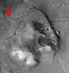
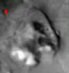
Images of the Fort taken by the MGS reveal that its interior is less geometrical than hinted at in the Viking pictures. Although the interior is subsided, it does not form a "courtyard" or "courtyards". The ramparts effect seen in the Viking images is thus an illusion. There seems to be no further reason to think that it is an unfinished arcology. This is a great disappointment because an arcology abandoned in it construction phase would probably have provided proof of the arcology model of Cydonia. Dr. Mark J. Carlotto has attributed the "rampart" and "courtyard" effect in the Viking images to the shadow thrown by the Fort's higher western ridge. However, I believe the main culprit is the dark colour of the landslides within the Fort's interior. Illustration #4 above is a deliberately degraded version of the MGS image (illustration #3) in order to replicate the Viking camera's level of resolution. It can be seen that the landslides immediately make the Fort's interior look very mysterious again.
There are two other surprises in the MGS images. Firstly, the eastern wall of the Fort has a very straight, vertical outer edge that is separated from the surrounding plain by a wide, deep rift. This continues around the western side of the Fort as the groove seen in the Viking images. The second surprise is the "promontories" that jut out into the interior of the Fort from its western ridge. These were only hinted at in the Viking images. C "Slip sliding away". The MGS images reveal that there are two major components to the Fort - the western ridge with its eastward pointing promontories, combined with a flat "deck" forming a lower level in the North and East. Both the eastern and northern parts of the Deck slope inwards towards the Forts interior. Dr. Mark J. Carlotto has devised a 3-D fly around animation of the new MGS images of the Fort that highlights the Fort's apparent tendency to slump into its centre. The animation takes a bit of time to download but is well worth the reader's examination, (click on this "stargate" µµµ).
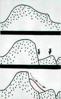
The diagram on the right illustrates what I think is happening in the Fort using a simplified West-East cross section. The top drawing represents how I envisage the original cross section to have looked like before the Fort began to slump. At this stage the Deck is at a higher elevation and is just an eastward extension of the western ridge of the Fort. In the middle drawing of the diagram the Deck section of the Fort then slides into the ground, creating a cliff on its inward side and the moat like rift with the plain on its outer side. The inner side of the Deck sinks further down than the outer side causing the slumped interior of the Fort. In the bottom drawing of the diagram the cliff left behind by the Deck's subsidence then gives way to create the landslides observed in the Fort's interior.
Geologically this process of dramatic shearing and rifting in a landscape can be explained by fault thrusting. However, quite why this process has been confined to the one square mile area of the Fort may be difficult to explain. It is also difficult to explain why the hypothetical inner fault line should have jig-sawed around the promontories. It will come as no surprise to the reader by now that I believe that a credible explanation for the Fort's interior subsidence is that the whole edifice is falling into collapsing underground chambers. In this arcology explanation for the Fort's subsidence the promontories resisted the downward slide of the Deck because they were supported by major structural support features that descend vertically down into the "basement" of the Fort.
However, this collapsing arcology explanation for the Fort's subsidence does not account very well on its own for the wide width of the moat like rift in the ground between the Fort's eastern wall and the surrounding plain. If, however, the plain to the East of the Fort is itself honeycombed with artificial spaces then the massive subsidence of the Deck would have easily triggered further collapses outside wall of the Fort. One feature that intrigued me about the Viking images of the Fort was the straight rift in the ground that stretched eastwards across the plain from the Fort's eastern wall. I wondered whether it might be part of a collapsed tunnel linking the fort with formations such as the "Face". The subsidence of the Fort would explain why this section of hypothetical tunnel collapsed. It may be evidence that the plain to the East and South of the Fort is indeed a kind of underground city. In the large illustration below I have coloured this possible collapsed tunnel in pink.
The catalyst for the Fort's dramatic subsidence is probably to be found in the fresh impact craters that straddle it. The largest of these craters is actually to be found on the surface of the Deck itself. These all appear to be part of the same event as fragments from some small comet or asteroid "shot gunned" into the ground. The violent ground waves from this multiple impact would have literally shaken the hypothetical Fort arcology apart.
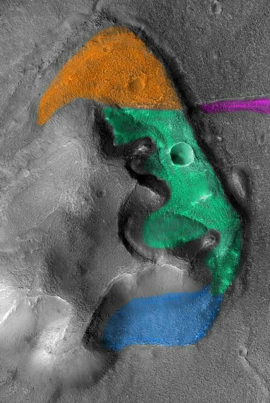
In the main illustration below I have coloured the Deck section of the Fort in green and orange. This is because although the northern part of the Deck seems to be tipping downwards towards its southern end it does not exhibit the same degree of subsidence as the part of the Deck coloured green does. In the illustration I have coloured in where I think the Deck extends below the landslides. The area I've coloured in blue is an intriguing one. Its outer edge is delineated by a low wall. Is this faint wall feature actually the original southern edge of the Fort? Although there is little to support the hypothesis, it may be the case that the blue area represents part of the Fort that has sunk down to ground level and is just an extension of the Deck. As a footnote, many parts of the surface of the Fort are covered with the same kind of "crocadile skin" effect that has already been noted on other Cydonian formations.
C C C C Cc C C C C C C C C C C C C
µ Next page µ Return to the main Arcology page |