Cydonia Quest C "Fossil" Arcologies in Ariadnes Colles? C Part Three
Analysis of HiRISE image sweeps PSP_007368_1445 and PSP_010717_1445
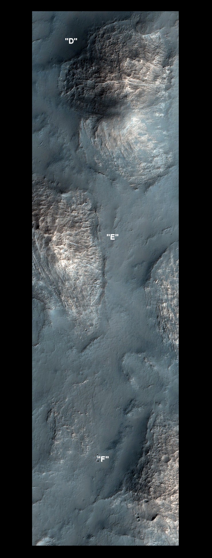
This analysis now moves on to another part of the Ariadnes Colles region.
Images 007368 and 010717 are an overlapping "stereo pair" of essentially the same piece of Martian ground. This should allow HiRISE scientists to computer map surface details in 3D if they have the means. (Both images are available here µµµ and here µµµ).
Image 007368 was taken at twice the resolution of 010717, so most of the following will use its data. Analysis will concentrate on the central part of 007368's false-colour image strip. The features in this area are displayed in the following illustration.
Viewing notes: The images on this page are quite large. Readers are advised to view these images in "full screen" mode - press the F11 key to enter "full screen" and then F11 again to return to the normal browser view.
Important details in images can be lost if viewed at too low a zoom level. Many readers will benefit by increasing their browser "zoom" by an increment or two - hold down the control key (Ctrl) and press the plus key (+). To return to standard zoom hold down the control key and press the minus key (-).
The three dimensional aspects of these images usually show up best when viewed in low lighting conditions.
The proposed "fossil" arcologies in this area differ in character from the ones studied in Parts 1 and 2.
Firstly, the remains of the structural "skeletons" are encased in a sedimentary rock that erodes differently and is not as bright as in the previous examples of Ariadnes A, B and C. There isn't the same visually helpful contrast between cells filled with dark sand and bright surrounding grids.
Secondly, these proposed "fossil" arcologies are not bounded by the distinctive "ramparts" seen in the previous examples of A, B and C. In terms of the arcology theory, it was suggested that "A", "B" and "C" began as natural mesas that were hollowed out and built upwards to create arcologies.
The appearance of the new features of Ariadnes D, E and F more closely match arcologies that were built from scratch, without using natural features. Erosion has resulted in these mounds retreating from their original boundaries. However, their original extent is marked by "lip and moat" features. This is most evident in the left side of Ariadnes "F" where there is a straight outer "lip" and a wide, eroded, "moat" between it and the rest of the mound. This can be seen in the large context image above.
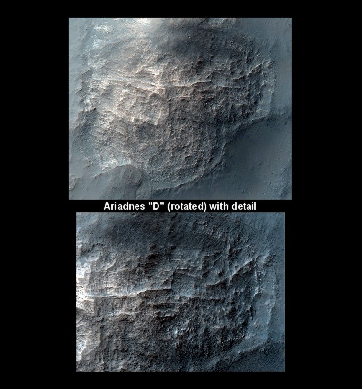
The illustration below shows Ariadnes "D" with the view rotated by 180 degrees compared to the first image.
The surface of this mound is covered in "fossil" grids of various sizes, and various states of exposure from the encasing rock. Its appearance fits in very well with the illustration used in Part 2 showing how the supporting "skeletons" of large structures become jumbled and twisted when they are collapsed.
In general Ariadnes "E" does not have grids with the same level of geometry as Ariadnes "D".
However, if the reader has their browser zoom set to a sufficient level, there is a distinct mesh-like effect running through the bigger undulations on the right side slope of "E". It is often the case that features that are sharp at low resolution become more smooth and rounded at high resolution. This is the case with this "mesh".
It takes a little work for the eyes to understand the following illustration of a section of the right side slope of "E", because the "mesh" co-exists with much larger and less distinct cells. The "mesh" turns out to be made up of walled cells and closely packed hollows about the sizes of large rooms or small buildings.
There is a tendency when viewing this illustration for the brain to turn the concave into the convex. Simply turning away and looking back again can cure this problem. Also, think of the lighting as coming from the bottom of the picture.
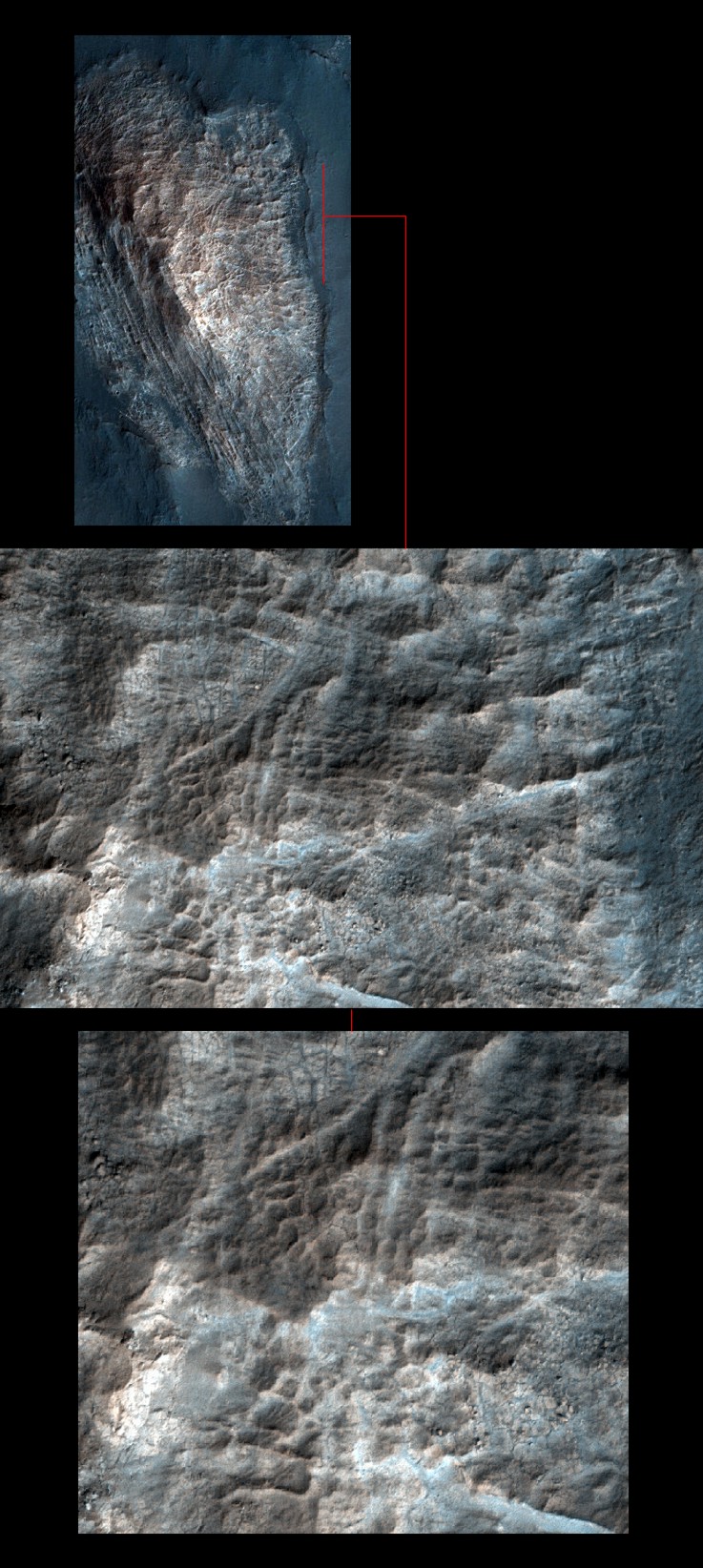
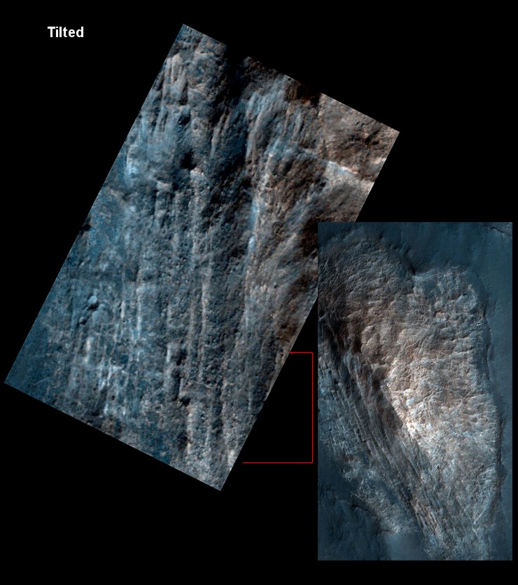
The context image for the above illustration is taken from the lower resolution member of the stereo image pair, namely 010717. This choice is because the false-colour version of 010717 captures more of the left-hand side of Ariadnes "E" than 007368. If the reader has their browser zoom set to a sufficient level they will notice a very box-like grid running along the bottom of the left side slope. This grid looks distinctly right angled in the context image
However, at higher resolution the parts of the grid next to the slope of "E" are partly obscured by large rocks, whilst the grids further out to the left are almost eroded away. (High resolution is desired, but it also has its drawbacks in terms of obscuring clutter). This is shown in the following illustration, but readers with a keen eye for geometry should still be able to make out the intensely right-angled square and rectangular "boxes" in the lower part of the picture.
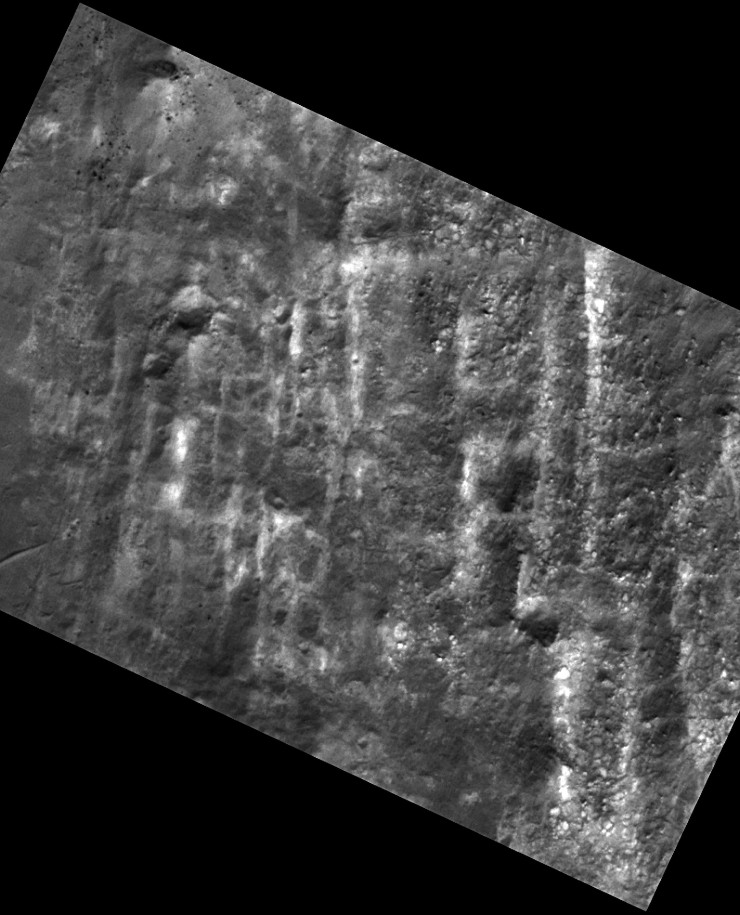
For a higher resolution view of these grids we must use the grayscale version of 007368, which is twice as detailed as 010717. The illustration below shows the highly geometric, right angled grid at the bottom of the previous picture. The image spans an area 600 feet (185 metres) across. C
C (Readers are encouraged to view this illustration in dull lighting, in "full screen" mode, and to experiment with a slightly higher browser zoom setting to get the best results).
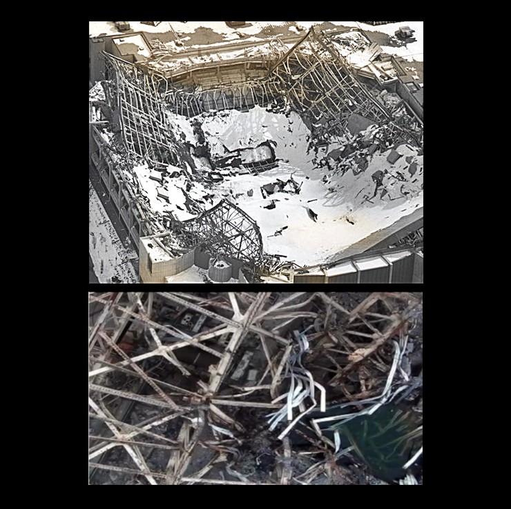
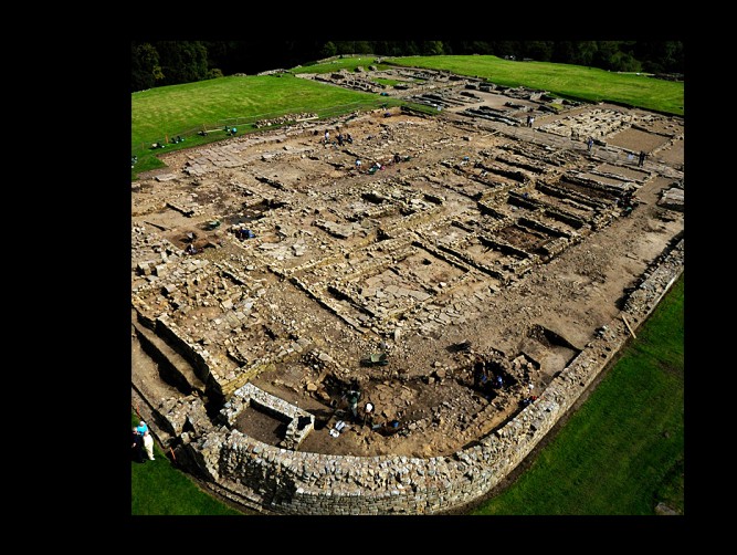
The overall effect of this section of Ariadnes "E" is very reminiscent of the present day remains of Roman forts, which were also set out to a strict right angled grid. The following illustration shows the Roman fort at Vindolanda.
Now to return from Earth to Mars. Although these grids are at ground level, the wider scope of the grayscale images reveals that they still lie inside the former boundary of the Ariadnes "E" mound.
So, in the proposed arcology these grids would have formed the foundation level. Unlike the structural "skeleton" higher up in the arcology, the geometry of these foundation structures would not have been distorted by the weight of the sediments that engulfed the whole structure.
As Ariadnes "E" has eroded inwards from the left side of the image, these "fossil" foundations have been exposed. On the left side they are smoother and more eroded simply because these have been exposed first. On the right side more foundations are being freshly exposed as the encasing sedimentary rock erodes back.
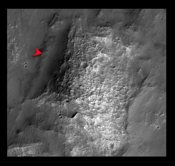
Ariadnes "F". The main thing of interest with Ariadnes "F" is its overall shape. It looks as if this proposed "fossil" arcology has best preserved its original shape from the original structure. If the straight "lip" (arrowed) and "moat" are included, then it looks like the arcology would have been a pyramidal structure with a rectangular base.
µ Back to Part 1 µ Back to Part 2 µ Forward to Part 4 µ Back to the Mars Page µ Back to Cydonia Quest Main Page c |