Cydonia Quest
C
Image Enhancements
C
The "Cliff" : Part One
The long awaited first MGS picture of the Cydonian feature known as the "Cliff" was amongst the batch of Cydonia images released by MSSS at the end of January 2001. However, due to two "transmission failures" in the MGS image strip M18-00606 only the northern half of the "Cliff" has been captured for us to study. At the time of writing there was no information available about the resolution of M18-00606 , but it appears to be no better than 10 to 15 feet. Atmospheric conditions above the "Cliff", however, seem to have been clear. A link to the new image can be found here, µµµ.
A brief description of the "Cliff". The "Cliff" is so named because that is what it appeared to be in earlier, poorly processed versions of images from the Viking orbiter - and unfortunately the name has stuck. In fact the "Cliff" is a straight wall (about one and a half miles in length) on top of a long, flat topped mesa, (as shown in the Viking image on the right). It plays an important part in Torun & Hoagland's General Geometrical Model of Cydonia. The "Cliff" points to the "Tholus" to the South and its two ends form important anchoring points to create tetrahedral angles with other Cydonian features in the model. The angle between the "Cliff", the "Tholus" and the improbably situated three sided pyramid on the rim of the crater in the Viking image is the tetrahedral angle of 19.5 degrees. For further details on the General Geometrical Model click on the following "stargate" µµµ .
Before MGS finally imaged the "Cliff" there was a geological mystery surrounding it and the huge Yuti-style crater nearby. This type of crater occurs on Mars when an asteroid or comet strikes ground that is saturated with water causing a great out-rush of water and shattered rock. As can be seen in the Viking image although there is plain evidence of ejecta material from the crater on either side of the "Cliff" and its mesa, none of it seems to have dammed up against this obvious obstacle or come to rest on top of it. There was therefore some question as to whether the "Cliff" and its mesa had mysteriously arrived on the landscape after the formation of the crater. This and other Cydonian mysteries can be read about in the following geological paper by James Erjavec and Ronald Nicks µµµ.
When we look at the ejecta flow from a Yuti-style crater it is tempting to think that the dynamics after the impact are the same as throwing a boulder into liquid mud, with water and rock splashing out miles into the air. In fact the characteristics of such an impact are as follows. A plume of molten rock shoots upwards at sub-orbital velocity so that most of the material ejected by the impact falls back to ground over the whole Martian surface. (In fact with Mars gravity being a third of Earth's a small amount of material will go into orbit or reach escape velocity). As Mars has a very tenuous atmosphere there will be a weak blast wave of steam and gas from vaporised rock. Far more powerful will be the ground wave which will deform and shatter the surface crust for miles around. This ground wave squeezes the water out of the crust so that it rushes outwards in a rock carrying "tidal" wave as horrible as the one in the film Deep Impact.
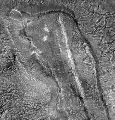
The mystery solved. The new image of the "Cliff" reveals a nightmare landscape of heaps of rock to the North and East (crater side) of the mesa where the "tidal" wave deposited them. The picture on the right is an enhanced but much reduced version of what the MGS has now imaged of the "Cliff" and its surroundings. Even in this reduced format it can be seen that the "tidal" wave of water surged up the eastern side of the mesa and deposited a huge jumble of rocks across the eastern edge of its flat top. There is even some incursion by these rock deposits on a small part of the base of the "Cliff's" wall, suggesting that both it and the mesa pre-date the creation of the crater. There is evidence that the wave of water, once it had dropped its burden of rocks, then flowed over the obstacle of the "Cliff" and down the other side of the mesa to dissipate over the plain beyond. The plain to the western side of the "Cliff" shows strong evidence of flood erosion, but little sign of deposited material in this new MGS image. The mesa on which the "Cliff" sits did, therefore, act as a dam to the outward flow of ejecta from the crater.
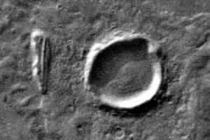
Now all that has to be explained is how the three sided pyramid came to be sitting on the north-eastern rim of the crater. Dr. Malin has been slowly directing MGS to image all the anomalies identified by Cydonia researchers. I have a suspicion that this crater pyramid will be imaged eventually.
This analysis of the "Cliff" contains many large images, so I've split it up into more than one page to allow easy down-loading. Click on the "Stargate" below to find out what the new MGS image has discovered about the true nature of the "Cliff".
µ The "Cliff" : Part Two