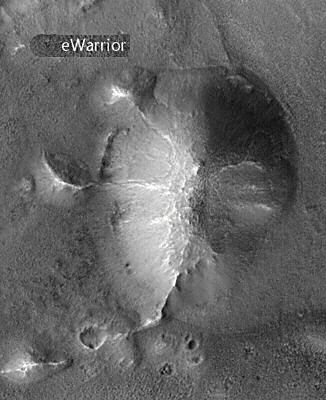
 Cydonia Quest C Testing the Arcology Model c The East Formation The East Formation forms one of the five highest points in the "City" surrounding the "City Square" mounds. Its location on a 1976 Viking context image can be seen by clicking on this "stargate"µµµ. General description. The western side of the East Formation has many architectural looking features. Firstly, there is the walled moat effect at its north-west base, which slowly becomes less pronounced as we move our attention towards the southern end of the formation (see MGS images display below). Then there are the ridge like spokes that come down from the top of the west side of the East formation to connect it with three satellite mounds - crossing the moat wall as they do so. These three satellite mounds are the beginning of a series of five mounds which are arranged along the path of an involute (exploding spiral) curve with significant mathematical properties. The northern most of the East Formation's satellite mounds could conceivably have eroded down from a four sided pyramid, the middle mound from a triangular pyramid, and the southern most from a symmetrical diamond pyramid. In addition to these satellite mounds there is an array of suspicious looking subsidence pits next to the southern most end of the East Formation. We will look at these at the end of this article.
|
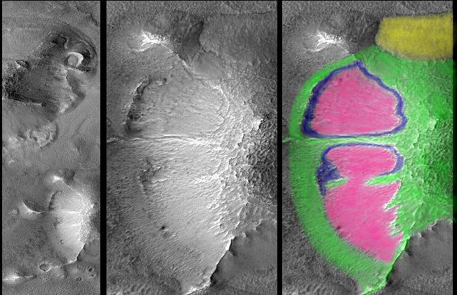
| c ccccccccCCCCccccccccccc Only the western side of the East Formation has been imaged by the MGS at high resolution, with the eastern side being captured at a very low resolution. The Electric Warrior website (see µµµ) has published the composite picture of these images seen above, which gives a good idea of what this remarkable anomaly must look like in the whole. C Possible subsidence features in the East Formation
In the photo illustration below I've coloured the parts of the East Formation that are eroding but not subsiding in green and the sections that appear to be subsiding inwards in pink. Zones were there is apparent lateral shearing and very evident downward shearing I've coloured in blue. The area coloured yellow seems to be some kind of debris flow from further up the slope. Although there is no walled moat in the southern half of the west side of the East Formation, there are a number of suspiciously placed pits. These may be the beginnings of cave-ins that will eventually extend the walled moat along the whole west side of the East Formation. A possible geological explanation for the walled moat is that the East Formation is a domed uplift of rock strata, each with different erosional qualities. In this geological model the East formation would be layered like an onion. The moat wall would represent harder rock that is eroding more slowly than the softer rock that once filled the space of the moat. I have a number of problems with this explanation. Firstly, the moat is a very prominent and deep affair, so why hasn't it simply been filled in by debris sliding down from higher up on the East Formation. (The subsidence model allows such a debris flow to simply disappear into underground space). Secondly, the geological "onion" model does not adequately explain the existence of the spokes. We would therefore have to complicate our geological model further to include the vertical intrusion into our "onion" layers of walls of harder rock, possibly due to the upwelling of molten lava along faults .......but then we would have to explain why this intrusive rock connects the East Formation with its satellite mounds. These satellite mounds don't look volcanic in nature. (This article continues below the following illustration). C
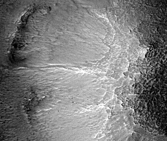
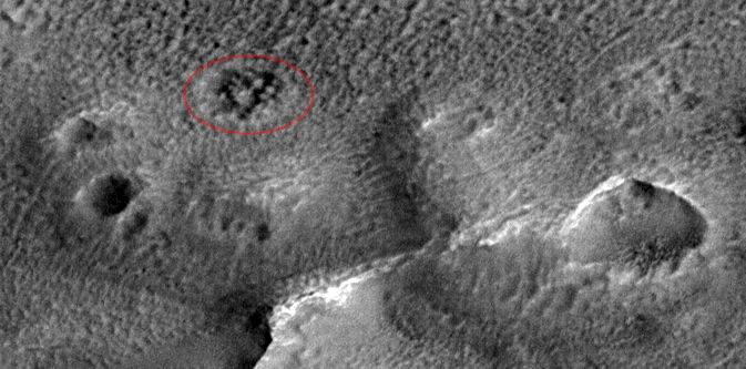
ccccccc c There may be more evidence of structural engineering on the surface of the "City" formations than Cydonia researchers think. In common with the West and North Formations, the East Formation has an irregular "crocodile skin" effect covering its highest levels. This involves shallow hollows defined by low, meandering "walls". Although there are some small areas where this large scale cellular pattern looks grid-like, the overall effect isn't very geometrical looking at close quarters. It is possible that these large, shallow cells are the eroded and distorted remains of a latticework of support structure within the outer shell of our hypothetical arcologies. Of course this could also just be a natural hollowing effect due to the fact that erosion on Mars is now almost entirely accounted for by dust storms. The following full resolution MGS image shows the top of the East Formation with its cellular patterns at full resolution. c cCCCCcc c Subsidence features on the southern edge of the East Formation If we examine the Electric Warrior composite image of the East Formation above, then we find an array of deep pits marking out a trapezium shape at the bottom of the picture. To the left of these we also find a larger, crater like depression. A full sized cropped image of this area has been reproduced below. I've aligned it with South at the top in the same way that it appears on the MSSS web-site. (Presumably the MGS spacecraft was angled in a southerly direction when the image was taken). On the right hand side of the picture we can see the large depression previously mentioned and we can also see that it is in a low mound. It does not appear to be an impact crater as there seems to be delicate structures in part of the interior. Neither does it feel quite right as a volcanic crater. Yet again, I think a credible explanation for this crater in the mound is that we are looking at the result of the mound collapsing into interior, empty space. How such an extensive cavern could have been formed naturally on Mars is difficult to explain. c ccCc c However, it is the deep pits on the left hand side of the image that look most artificial. They are self evidently the result of surface collapse into subterranean spaces. It is interesting that they are also associated with very low mounds. The most artificial looking pits are those along the front of the mound on the lower right of the pit array - but especially the top most of this array of surface collapses (circled in red). The collapse of the ground here appears to have exposed a grid like pattern of support pillars - which if true is unlikely to be anything else but the result of artificial construction. The cropped image I have used here is about half a kilometre across - so we're not talking about extreme image enlargement of small features. If anything I'm surprised that the image is so fuzzy given that it is supposed to have a resolution of 1.5 metres. It would be nice if TEM published one of their state of the art image enhancements of these features on their web-site. The 40% and 100% source images I have used in this article can be can be found on Malin Space Science System's official Cydonia web page. Just click on the following "stargate" for the necessary trip through hypertextual cyberspace - but why not leave that until you've read all the Cydonia Quest articles on the Arcology model? µµµ c µ Next page µ Return to the main Arcology page |
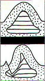 A credible explanation for the moat and its wall is that the moat wall is the result of massive subsidence down and into empty spaces inside and below the East Formation. If the East formation does contain empty spaces then there is no way of knowing how it is arranged. However, in the appended diagram on the left I've represented it as normal building floors using horizontal lines. In the diagram the East Formation's walled moat is created by internal collapse drawing part of the external shell of our hypothetical arcology downwards and inwards as if it was on a hinge. In this model the spokes running down the sides of the East Formation are reinforced parts of the outer shell that acted as massive support structures. These spokes have therefore withstood the subsidence.