Cydonia Quest C Testing the Arcology Model
c The North Formation
The North Formation forms one of the five highest points in the "City" surrounding the "City Square" mounds. Its location on a 1976 Viking context image can be seen by clicking on this "stargate"µµµ.
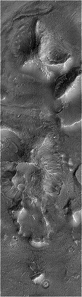
General description. The North Formation has also been called the "Collapsed Pyramid". On Viking images the North Formation appears as a faceted hill where one side appears to have caved in, forming a vaguely triangular bowl. The "inside" edges of this concave depression are marked by a steep slope, but the "outside" edge has a gentler slope that might have been missed by the Viking camera if the Sun angle had not been so low. Obviously, this concave depression is a prime candidate for being a subsidence feature in the arcology model. C Possible subsidence feature in the North Formation
The North Formation was captured by the MGS spacecraft in its second ever image of the Cydonia formations. The level of picture resolution was 2.5 metres compared to the 1.5 metres in the image used when investigating the East Formation in the previous article. As a result each pixel of information collected by MGS in this image covers nearly three times as much Cydonian terrain as the East Formation image, with a consequent loss of detail. Moreover, the Martian sky over Cydonia was hazy with dust when the North Formation was imaged, which obscured the view. Throw in the fact that the image was transmitted back to Earth digitally compressed by 50% and we're not talking about a very clear picture here. Not only are details difficult to make out, but even the general lie of the land in some instances.
The MSSS Cydonia web page only provides an unprocessed version of the full sized image of the North Formation. However, there are full sized processed images on a JPL/NASA web page that can be accessed by clicking here µµµ.
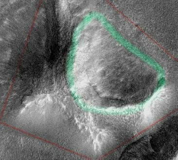
In the MGS context image below the North Formation is the top most hill. It is not readily apparent from this image that it does contain a large depression because the high Sun angle is not high lighting the gentle slopes on the outer edge of the formation. In the larger image below I have used a green line to indicate where the edges of the depression are. The darker patch within this outline is shadowing caused by the concave nature of the depression. Now that we have made sense of the actual lie of the land it can be seen that if the North Formation is a ruined arcology then it was originally four sided. Each side would have been of a different length with four facets of different sizes. (Hardly a classic pyramid shape then). I've outlined this proposed outer boundary for the hypothetical arcology in red in the main illustration below.
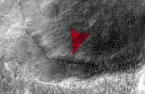
It would be easy to think that the material at the bottom of the North Formation's depression has been blown in over the lip of the low, outer edge. However, if we look carefully we see at least one distinct "crater" like feature within the depression which would not have held its shape in loose material. It reasonable to assume from this that the floor of the depression is a hard, "rocky" surface. The hole story. In terms of the arcology theory the depression in the North Formation would have been formed by the collapse of an underground chamber. As a result of this collapse the roof flipped downwards into the void like a lid on a hinge. The outer, straight edge of the North Formation depression represents this hypothetical hinge point. If we look down the inner, steep wall of the depression we find that it is separated from our hypothetical lid by a pronounced fissure. This fissure is indicated by the red pointer in the crop taken from the full sized image. In our "lid" model the fissure exists due to the roof of the hypothetical chamber shearing away from the top of the North Formation and then skidding down the interior wall of the chamber. If this model is correct then there may be other such chambers within the North Formation. Hopefully MSSS will release new, clearer images of the North and West Formations before the MGS mission ends so we can look for evidence of exposed structural engineering features.
Although there may be a geological explanation for the North Formation depression, that does not involve subsidence into interior empty space, I have ruled out vulcanism in my own mind. The angular outlines of the North Formation and the shape of the depression do not look very much like a volcano.
C C C C µ Return to the main Arcology page |