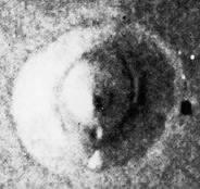
Cydonia Quest C Testing the Arcology Model c The Tholus Formation The Tholus is a conical hill located approximately twenty miles East of the "City Square". Its peak forms a right angle with the peak of the D&M Pyramid and the "Cliff" in a triangle with internal angles progressing through 30, 60 and 90 degrees, (see µµµ). Its location on a 1976 Viking context image can be seen by clicking on this "stargate"µµµ.
General description. Although it is a mile wide at its circular base the Tholus is only 1,500 feet tall. The Viking image showed the Tholus's slopes encircled by a series of grooves. One of these appeared to spiral up towards the peak of the Tholus whilst another created a ledge halfway up the formation. There was an obvious crater like hole on the southern part of this ledge. To my eye there also appeared to be some dimples just below the eastern side of the Tholus's peak. The conical nature of the Tholus marked it out as a possible cinder cone despite the lack of an obvious volcanic crater. c ccccccccccccccccccccccccccccccccccccc
C Possible subsidence features in the Tholus
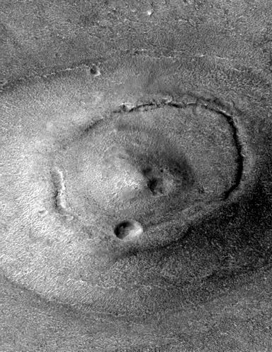
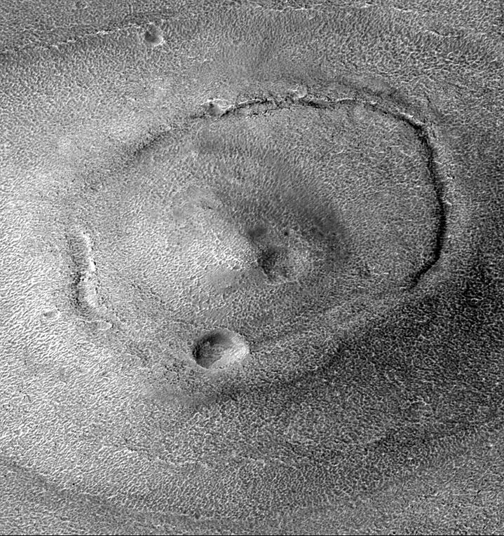
The 1976 Viking context image above shows the features just described - but not as well as I had hoped. (I suspect this image began life as one of Dr. Mark J. Carlotto's original image enhancements of Cydonia). In July 1999 the MGS re-imaged the Tholus at a resolution of 3.1 metres per computer screen pixel, (see µµµ). The Sun angle seems to have been too high to highlight the spiral groove, but the encircling groove was very prominent. As can be seen in the illustration below it was revealed to be a fissure along much of its length. The MGS image also confirmed the existence of the dimples near the peak of the Tholus. C Cccccccccccccccccccccccccc Note, the MGS image used in this article has not been rectified for the camera angle distortions that have squashed the North-South aspect of the picture. The base of the Tholus is actually more circular as seen in the previous Viking context image. c The Enterprise Mission analysis of the Tholus concentrated on the tetrahedral shape of the top most part of the formation. There was an assumption that the Tholus Tetrahedron had eroded down from a sharply defined tetrahedral pyramid. I'm not so sure about this. Some parts of the surface of the Tholus Tetrahedron look as if they might be fairly well preserved. If this is true then (assuming the artificiality hypothesis is true) the original shape looks to have been a "morph" between a tetrahedron and a hemisphere. Richard Hoagland's hyperdimensional model emphasises the importance of the geometry of tetrahedrons enclosed within spheres - so maybe such a "morphed" shape should come as no surprise. Tholus or Thoufflé? In terms of this investigation of the arcology model, the groove/fissure that encircles the upper parts of the Tholus may be a highly significant subsidence feature. As the illustration above shows, the slope of the Tholus between the encircling fissure and the tetrahedral peak flattens out somewhat. It's as if the central parts of the Tholus are sinking back into its base like some giant soufflé. Such a process of subsidence would be easy to explain if the Tholus was full of empty artificial spaces as the arcology model predicts. The encircling fissure would then be the result of shearing between the subsiding inner regions of the Tholus and its outer parts. This soufflé model of the Tholus predicts that it was originally taller and more conical than it is now. The next illustration shows the Tholus at the full 3.1 metre per pixel resolution captured by the MGS. It has been enhanced to emphasise every little feature on its surface. c
As always with these outsized images the reader is advised to use the "View" then "Full Screen" options from the menu bar at the top of their browser screens to see more of the image clearly. C High quality, enlarged enhancements by TEM reveal that underneath the skin of the Tholus there seems to be a honeycomb structure strongly suggestive of structural engineering, which is now twisted and in ruins. (Much of this is also evident in the previous Cydonia Quest enhancement above). This can be seen in and around the dimples on the side of the Tholus Tetrahedron and in the "crater" feature on the southern side of the encircling groove/fissure. (These TEM enhancements can be seen by clicking on this "stargate" µµµ and then by clicking again on the two thumbnail pictures at the very bottom of TEM's picture display). The dimples seem to be the result of some kind of damage to the Tholus Tetrahedron that has uncovered its internal structure, (see µµµ). The "crater" feature that TEM has labelled an "entrance" may actually have been created by a meteorite impact, but its form is unconventional. The floor of the "crater" distinctly slopes downward from its eastern end to its western end. Moreover, there is honeycombed "masonry" hanging down from the western lip onto the floor. There is an impression of a tunnel continuing under the western lip of the proposed "entrance", but the hanging "masonry" obscures our view, (see µµµ). µ Next page µ Return to the main Arcology page |