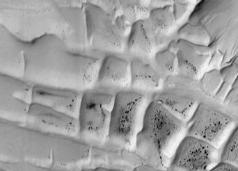
 Cydonia Quest C Image Enhancements C Further Experimental Analysis of the First Infra-red Image of Cydonia Part Four C What do the Cydonia thermal grids represent? The thermal grids that have been identified in the previous parts of this analysis have been imaged at a fairly low resolution of 100 metres per pixel. At this level of detail they do not necessarily scream out "artificiality!" if viewed in isolation. In the BUMP mapped enhancements the grids are made to look like walls or embankments based on their infra-red brightness. The fact that some of the geometrical thermal grid in the area close to the "Fort" actually breaks the surface as barely perceptible embankments in visible light images indicates that the grid seen in the infra-red images is in fact made up of buried "walls". (See beginning of Part Two µµµ). Grid like structures of walls are not unknown on the surface of Mars. The illustration below shows a section of "Inca City". The cells in the grid in this particular case are about three to four times larger than those seen in the Cydonia infra-red images. Malin Space Science Systems have recently discovered that "Inca City" is part of a much larger circular structure. They put forward two alternative geological theories as to how "Inca City" could have been formed, but admit that both could be incorrect and emphasise the geological mystery surrounding the formation. (Click next "stargate" to read the MSSS article µµµ). Neither of the two theories can be applied to the Cydonia grids as they require an impact event. The following link shows some grid like walls noted in Huo Hsing Vallis by the Mars Odyssey team (click µµµ), which is also presented with a possible geological explanation. However, to show up in 100 metre resolution infra-red imaging the walls buried at Cydonia must be substantially wider than those seen in the visible light image of Huo Hsing Vallis.
|
Of course on much smaller scales nature can play some very strange tricks indeed - see µµµ. C CCCCCCCCCCCCCCCC C Of course the thermal grids at Cydonia are not an isolated phenomena. They must be seen in the contextual Cydonia setting of a bi-symmetrical five sided pyramid, a geometrical bi-symmetrical platform with what looks like a face sculpture on top of it, a series of similar mounds arranged in an unlikely geometrical pattern - and any number of other odd formations and smaller grid-like landscapes seen in high resolution imagery of the area. As this website is dedicated to exploring the artificiality hypothesis for Cydonia some speculation as to what these thermal walls represent as possible constructions is in order. Given the width of the thermal walls they may actually represent the flattened remains of some kind of habitation themselves. Even if they are just earthen embankments the purpose of the cells between the walls is intriguing. A reasonable proposal is that they were intended to create warmer micro-climates, especially if they were glazed over as one giant greenhouse. Recent simulations of Mars's delinquent polar axis have shown that the planet could have been watery with a thicker atmosphere as little as five million years ago (µµµ), which makes such a scenario feasible. The sheltered cells between the walled structures could have housed anything from water reservoirs to horticulture and gardens. One interesting thing about the thermal grids in the vicinity of the "Fort" is that they have no sharply defined boundary. They just become fainter the further away from the "Fort" they are until they become indistinguishable from the "noise" in the image. This progression suggests that they are being buried deeper and deeper beneath the surface. In January 2003 the Cydonia infra-red image on which this analysis has been based was finally released in raw format on the Planetary Database System (PDS) indexed as I0172003. This will give a chance for Cydonia researchers with image processing skills to clean the image up using their own expertise. This may lead to more of the thermal grid being isolated from the underlying "noise" than has been possible using the image processed for the Mars Odyssey website last 24th July. (This article continues below the illustration below). c
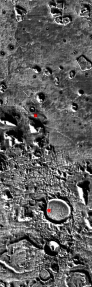
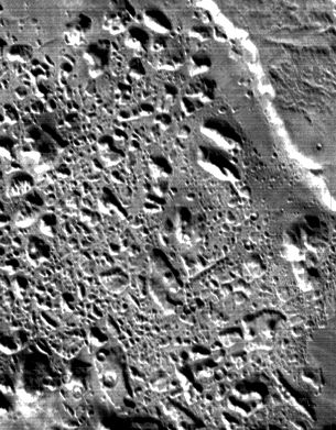
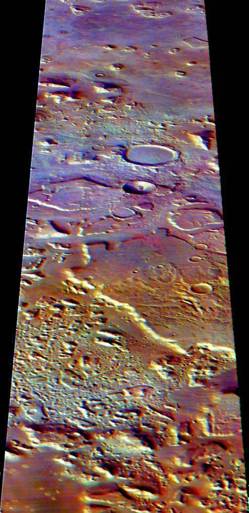
cccccccccccccccccccccccccccccc c The Grid-like Layout of the Southern Cydonia Landscape As well as providing data about the thermal properties of the Cydonia landscape, the THEMIS daylight infra-red images have also provided topological imaging for very large swathes of Cydonia similar to what we might see in visible light imaging. The layout of the hills and knolls immediately to the South of the classic Cydonia "monuments" area has a strong rectilinear pattern. The illustration above has been processed in such a way as to amplify the appearance of every small bump in the ground in the area between the D&M Pyramid and a large flat floored crater (both marked in red). If one views this image well back from the computer screen then it can be seen that the small hills tend to line up in rows and that the landscape is dissected by a grid of straight furrows. It is very reminiscent of a city street plan after the buildings have collapsed into mounds of rubble, then been buried by drifting sand. A geological explanation would be that we are just seeing a landscape that has eroded quickest along weakness provided by a tight grid of intersecting fault lines. However, given the close proximity to the five sided D&M Pyramid the area deserves closer inspection. It would be interesting to see what a night-time infra-red image taken in optimal conditions may reveal about the site - or preferably a powerful ground penetrating radar. Unfortunately the latter won't be going to Mars in the foreseeable future. Some of the images on this page shoot off the top and bottom of the computer screen. To get a better view of them readers browsing with Microsoft Explorer can get a better view by clicking "View" on their toolbar and then choosing "Full Screen" from the dialogue box. The appearance of the screen can be returned to normal by clicking the "restore" button in the top right of the screen. Netscape users probably have a similar facility. The area that has attracted most comment on the internet is much further South than the one described above and involves a dense, broken landscape of mesas and hills. It is best covered in the second daylight IR image to be released to the public which is indexed as I0204002 in the PDS. The images below show the area in question. C
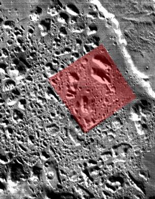
C The irregular outlines of most of the outcroppings means that it is not immediately apparent that this is an organised landscape. However, if the reader views the imagery in a relaxed manner then it soon becomes apparent that everything is arranged around an invisible system of grids. Once again this effect could be due to erosional patterns in a landscape heavily criss-crossed by fracture lines. The area does seem to have once been part of the plateau seen in the top right of the picture. Yet there are some hints that this in an artificial landscape that is being exhumed by erosion. More than one commentator has pointed out the outline of a large square, which is shaded red in the right hand illustration above. There are also a few cases of twin hills. The easiest pair to spot are the two large hills in the top corner of the "square". These are very similar in size, shape and alignment. It is an awe inspiring speculation, but are we seeing the exhumation of a huge city of collapsed arcologies from overlying sediment? Dr. Mark Carlotto has written of this area - "The 'rubble' consists of a variety of features (on the order of several hundred meters in size) that appear (in places) to lie in organized patterns. In particular, several rectangular arrangements can be seen. Some of these arrangements are aligned, more or less, in the direction of the crustal dichotomy in this part of Mars. On Earth, in the Middle East for example, it would certainly be seen as a possible archaeological site. But it is on Mars.
Will this new discovery be dismissed as another optical illusion, like the Face about 120 kilometres to the north? Or might some brave planetary scientist at ASU, JPL, or NASA finally consider the possibility that the growing list of 'coincidences' of symmetries, alignments, and enigmatic features may not be a coincidence after all." Finally, the illustration below is a crude attempt to create a false perspective picture of Cydonia looking North from this area towards the D&M Pyramid and "Face" using one of Keith Laney's IR false colour treatments of I0172003, (see µµµ). Best seen in "Full Screen" mode. C
cccccccccccccccccccc µ Return to Part 1 µ Return to Part 2 µ Return to Part 3 µ Return to the Enhancements page
|