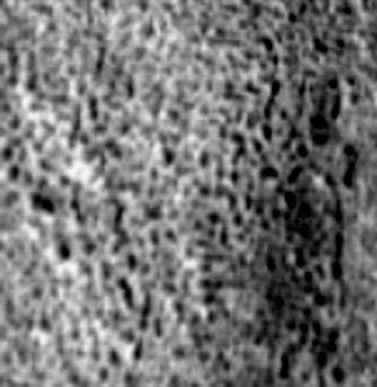
 Cydonia Quest C Image Enhancements C Buried Rectilinear Features in Cydonia At the time of writing there was still an unresolved debate amongst Cydonia researchers as to whether a leaked version of a Mars Odyssey set of multi-spectral infra-red images of the "monuments" area was a toxic leak of disinformation or a much needed blast of the oxygen of truth. Stretched de-correlation image analysis of this leaked infra-red (IR) image set by Keith Laney, which was published on the Enterprise Mission website, showed evidence of extensive, large scale grid structures buried under the Cydonia plain, (click "stargate" for details µµµ). Cydonia Quest already knew from its own image analysis of Mars Global Surveyor's (MGS) high resolution imagery that there was an area within the boundaries of the leaked infra-red image where there was strong evidence in visual light of buried structures. This was the locality of the Cydonia "Grill" situated between "Bright Mounds" E, D and B, (click "stargate" for details µµµ). The enlargement of a sample area of the "Grill" below shows a highly grid-like landscape of building sized pits. The "Grill" has been imaged three times at the low end of its resolution capability by the MGS, but it appears to be the same kind of thing as the "Southern Suburbs" which can be seen by clicking this "stargate" µµµ.
|
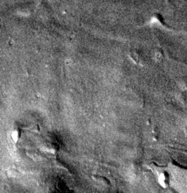
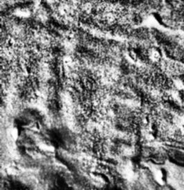
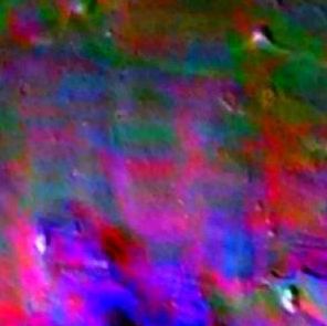
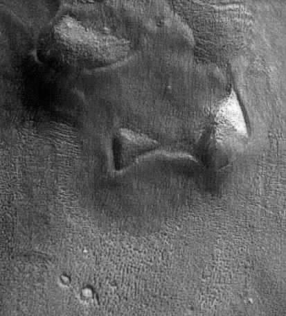
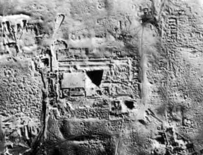
| C cccccccccccccccccccccccccc c It was therefore only natural that Cydonia Quest should zero in on Laney's analysis of the leaked IR image in the area of the Cydonia "Grill". Laney had provided pictures to the Enterprise Mission that super-imposed the 100 metre resolution leaked IR data over the 19 metre resolution visible light image of Cydonia, also taken by Mars Odyssey. Examination of the "Grill" area in Laney's images revealed that the overlay of false colour IR grid patterns seemed to pin point a barely visible large scale rectilinear pattern in the gentle undulations in the lie of the land. The first two images below show progressive image enhancements of the visible light image of the "Grill" area that aim to exaggerate the subtle changes in surface elevation. The third image is one of Laney's false colour IR overlays of the same area derived from the leaked IR image of Cydonia. C ccccccccccccccccccccccccccccccc ccccccccccccccccccccccccccccccc cccccccccccccccccccccccccccccc C As the first two images reveal there is a large rectilinear grid of shallow ridges and hollows in this landscape. On Earth such images would suggest a new archaeological discovery, perhaps the buried remains of an ancient city. This impression would be doubly re-inforced by the fact that the site is overlooked by what look like pyramidal structures in various states of decay, as shown by the only MGS image - at the lowest end of its resolution - of Bright Mound "E" below, (South is top in this picture). C cccccccccccccccccccccc C The fact that over a large part of this new and massive rectilinear formation the ground is also progressively caving into a grid of hidden hollows would (on Earth) demand further archaeological investigation. This article is not the place to evaluate the veracity of the leaked IR image. However, within the "Grill" area there is a correlation between a subtle rectilinear lie of the land and the false colour IR overlays derived from the leaked Cydonia IR image, (see µµµ). The discovery of this larger pattern in the "Grill" area was entirely inspired by Laney's images - so even if the leaked Cydonia IR image is eventually proven to be a fake, it has proven to be a useful tool in this case. Finally, as example of what buried archaeological features can look like from the air, the aerial photo below was taken in 1933 of the partially excavated Saqqara site in Egypt. As well as Djoser's Pyramid (centre) there are also three smaller pyramids in the picture and a mass of buried complexes. C cccccccccccccccccccccc c µ Return to the Enhancements page µ Return to the main Mars page µ Return to the Cydonia Quest main page |