Cydonia Quest C D&M Pyramid - Examining the "Girders" C Part Five C
This page contains some very large images. Readers are advised to view this page in "full screen" mode to fit more of each image onto the screen at the same time. Press the F11 key to enter "full screen" and then F11 again to return to the normal browser view.
Some readers will also benefit by increasing their browser "zoom" by an increment - hold down the control key (Ctrl) and press the plus key (+). To return to standard zoom hold down the control key and press the minus key (-). For tips about adjusting the appearance of your browser display click here.
Viewing the images in low lighting conditions also makes details easier to see.
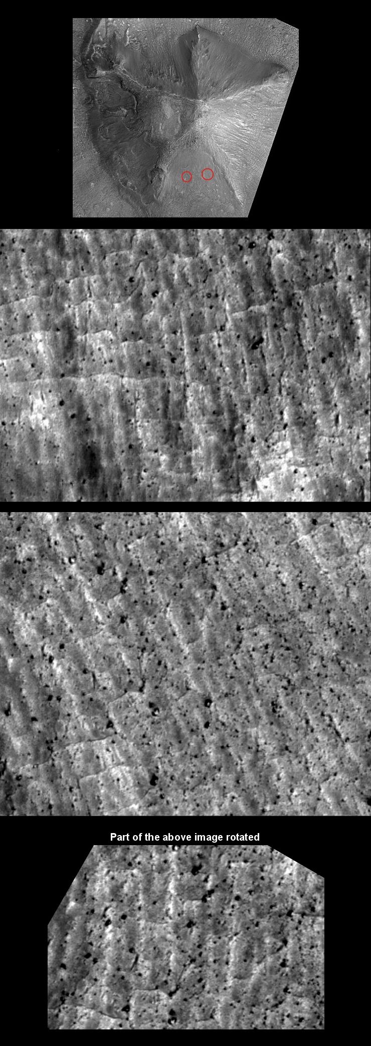
C The D&M Pyramid's northern facet
The illustration poster above shows two areas on the surface of the D&M Pyramid's northern facet. (The images in the poster are aligned to look up-slope). These areas have a similar pattern of four sided raised grids to those that were also seen on the eastern facet in Part 4. The northern facet is more densely covered with huge rubble blocks than any of the D&M's other facets. This obscuration makes the grid patterns less easy to discern compared to the examples that were examined on the eastern facet.
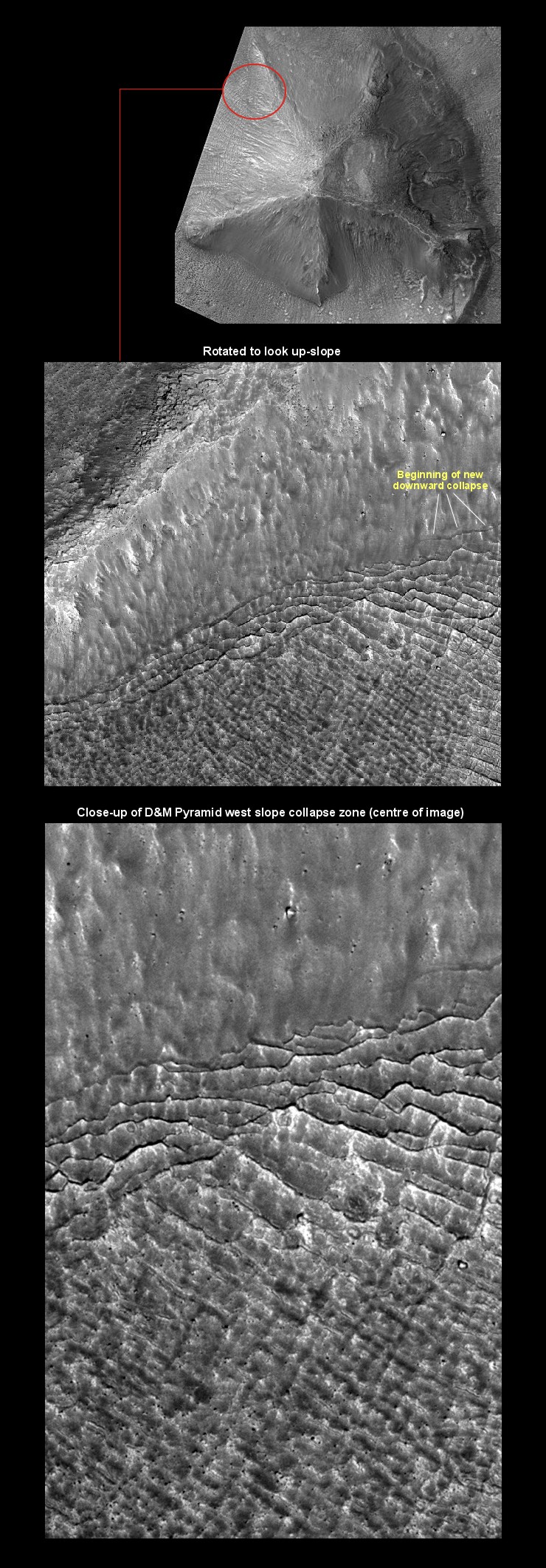
c The D&M Pyramid's western facet
The western facet of the D&M Pyramid is the most exposed to Cydonia's prevailing wind direction. It is therefore more subject to wind erosion than the other facets. Whereas the overall surface shape of the eastern side tends towards the convex, the surface shape of the western side tends towards the concave. (The possibility that both facets were originally convex was explored by Cydonia Quest back in 2004 when the D&M began to be imaged by the Mars Global Surveyor spacecraft, see µµµ).
However, the latest HiRISE images of the D&M indicate that wind erosion is not the only reason why the western facet tends towards the concave. The facet also appears to be breaking up and then simultaneously sagging inwards, helping to create the concave surface shape.
We can deduce that the surface is not breaking up and then merely land-sliding down the slope. If it was then the debris would flow over the top of the "suburbs" grid pattern covering the plain at the foot of the west facet, (see µµµ). The superb one foot per pixel resolution of the HiRISE image shows that it is not doing this. That means the facet is breaking up and subsiding downwards vertically at 90 degrees. This part of the D&M is undergoing a slow, progressive collapse - and if it is not flowing outwards then it must be becoming more compressed. The hypothesis that the D&M is an artificial arcology easily explains such vertical compression through the collapse of empty spaces within the interior.
The annotation in the previous illustration poster shows how lateral fissures in the west side of the D&M are progressively creeping higher and higher up the facet. Near the bottom of the facet - where this subsidence began and is most advanced – the D&M's surface evolves into an increasingly geometric raised grid. The arcology model proposes that the box-like structure of the D&M's interior is being revealed as the subsidence progresses up the facet. As the western facet breaks up, the loose rubble and dust that buried this structure is free to subside deeper down into the D&M's interior spaces, exposing the grid.
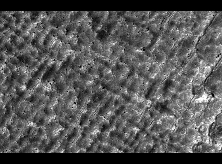
The next image is a close-up of the raised grid as it appears at the very bottom of the facet. (The image width is about 970 feet). The appearance is spookily similar to a bombed out city based around a right-angled street plan.
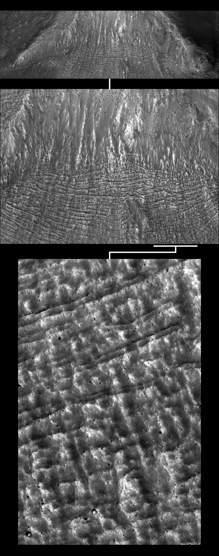
The final illustration poster provides a more distant viewpoint of the lateral fissures and four sided grids that are slowly growing up the western facet. The subsidence still seems to be in action, so in the future even more of this facet will be covered with grids. The last image in the illustration shows a full resolution strip up another part of the facet. Yet again the break-up of the surface evolves from newer fissures higher up the facet to four sided grids lower down the facet.
Conclusion
There are three methods we can use to remotely identify possible arcologies on Mars.
1) We can look for signs of geometrical design in the layout and floor-plans of the suspected arcologies. Seen at lower resolutions the D&M Pyramid clearly shows this type geometry.
2) Look for mounds that seem to have anomalous implosions into interior voids that a natural hill shouldn't have. The D&M's "collapsed" satellite mound, the curious depression at the top of the eastern facet, and the break-up patterns on the lower western facet are all evidence for possible ancient implosion events.
3) Look for ruined structural features. These could be anything from room sized grids to massive support walls and beams. The abundant honeycombing and raised grids emerging from the surface of the D&M are all evidence of possible structural/architectural features.
The new HiRISE images of the D&M Pyramid don't prove that it is an artificial arcology - but they do advance the evidence that this is the case.
Click the links below to continue reading this article.
µ Back to Part 1 µ Back to Part 2 µ Back to Part 3 µ Back to Part 4 µ Back to the Mars Page µ Back to Cydonia Quest Main Page C
|