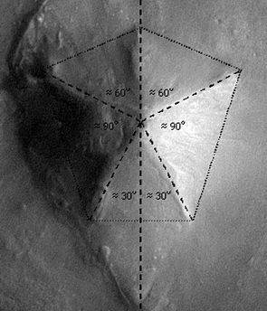
 Cydonia Quest C Image Enhancements C c The First MOC Images of the D&M Pyramid Part One Something that had been eagerly awaited by Cydonia researchers since the Mars Global Surveyor's MOC camera took its first images of Cydonia in April 1998 was high resolution imagery of the five sided D&M Pyramid. By the summer of 2003 the MGS had taken more than half a dozen images of the nearby "Face" and surveyed many other Cydonia formations - but inexplicably had failed to image the D&M. This was despite the discovery from low resolution imagery taken by the Mars Odyssey, which was released in the spring of 2002, that the D&M seemed to have some unusual geometrical properties, (click this "stargate" for details µµµ). The diagram below, taken from Dr. Mark Carlotto's website illustrates these properties, (note: north is at the bottom of this particular image). Click µµµ for Carlotto's full analysis. C ccccccccccccccccccccccccccccccc c In the summer of 2003 Malin Space Science Systems (who operate the MGS) began a public request imaging service. I registered with the service and put in a request for the MGS to take an image straight through the centre of the D&M at the highest possible resolution of approximately 1.5 metres (5 feet) per image pixel. Then unexpectedly in September 2003 the MGS "image of the day" webpage published two image strips of the D&M taken through its east and west sides, but which excluded its central parts, (see µµµ). These new images were at quite a low resolution by the standards of the MOC camera and the image strip of the D&M's eastern side was full of noise. I therefore decided not to publish a new article on the D&M but to wait and see if better images came along later. The caption on the MSSS page promised that an effort was being made to take higher resolution images of this formation.
|
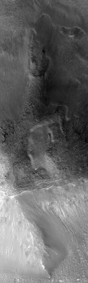
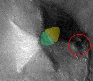
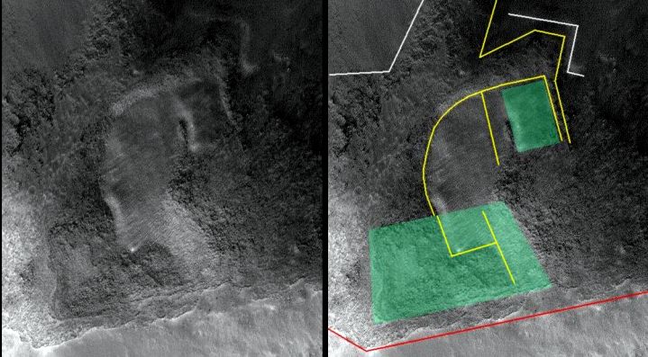
In mid December I received an e-mail from MSSS informing me that the image of the D&M that I'd requested was now available, (see µµµ). As this image showed some interesting things and allowed a full MOC composite image to be constructed, now seemed to be the moment to publish a preliminary analysis of what the MGS had discovered about the D&M Pyramid. A much reduced version of the part of this new image that covers the centre of the D&M is shown below. C ccccccccccccccccccccccccccc As always with these outsized images the reader is advised to use the "View" then "Full Screen" options from the menu bar at the top of their browser screens to see the images more clearly. c Geometry revealed in the east facet depression. Since the Viking spacecraft images were taken in 1976 it has been known that there is a depression near the top of the eastern facet of the D&M and an apparent bulge down the slope from it. These features are shown in the Mars Odyssey picture below, with the depression marked in green and the "bulge" in yellow. A collapsed satellite mound is circled in red, but this will be covered in Part 2. C ccccccccccccccccccccccccccccccc C The new high resolution MGS image reveals that the southern part of this depression comprises a sub-depression of a roughly trapezium shape. Around 80% of the boundary of this shape is marked out by a downward shear in the D&M surface. Another oblong feature to be seen in the image is a raised platform surrounded by rough, raised surfaces on most sides. Both these features are shaded schematically in green in the illustration below. This illustration also has a number of lines drawn on it indicating edges, where smooth areas meet rough areas, and the general trend of some shallow furrows. (All of this diagrammatic "annotation" is schematic only as my mouse drawing abilities deserted me with this diagram). There does seem to be a strong sense of an underlying geometry to the eastern facet of the D&M. C
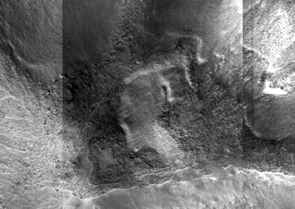
C The following image shows the trapezium shaped depression at full resolution. There are reasons to believe that this depression has been caused by subsidence. In the arcology model this subsidence would be explained by the collapse of a geometrically shaped volume of hollow space deep within the D&M. The geometrical shape of this collapse would then be transferred up to the surface in an hour glass fashion. The first reason for thinking the depression is the result of subsidence is that there are clear signs of a sharp downward shearing at its edges. The second is to do with the cellular/honeycomb pattern that is to be seen on the D&M's surface outside of and to the left of the depression. Although much of the bottom is filled with rubble, it is noticeable that in the centre-left part of the depression this cellular/honeycombing pattern continues in a way that suggests the surface of the D&M has slipped into a hole. C
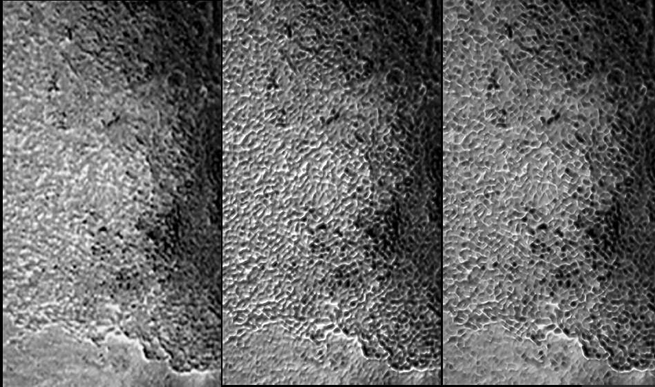
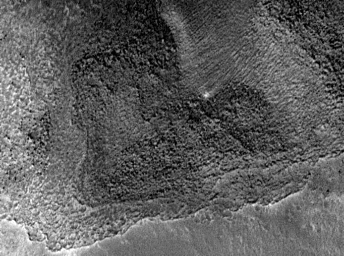
c The grid-like cellular pattern of shallow hollows seen on parts of the surface of the D&M is also seen on the exposed parts of many other possible arcologies (super buildings) at Cydonia, including the East Formation (µµµ) and the "Fort" (µµµ). Considering them as possible artificial features then they could be the remains of hollow "rooms" that have been unevenly eroded into and are now almost filled with rubble. However, the Cydonia Quest model of these possible arcologies is that they have very thick shells - think limpets - and that the ridge lines (five in the case of the D&M) are the exposed tops of massively thick support walls.
|
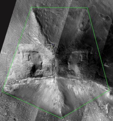
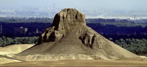
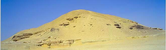
A clue to how these hypothetical shells and walls could have been built is provided by the way in which the Hoover Dam was constructed. The designers realised that if the concrete infill of the dam was poured into one single cavity in the structure, then it would take forever to set. They therefore built the structure of the dam incrementally upwards as storeys of small, prefabricated, reinforced concrete rooms or boxes. As each room/box was completed the concrete infill was poured into it and only took a few days to set adequately. If the protective shells of the hypothetical Cydonia arcologies were built with a reinforced honeycomb structure, with the spaces infilled with non-reinforced material, then we would expect this infill material to erode quicker that the honeycomb. This would explain the eroded grid-like pattern of walls and hollows on the exposed surfaces of the Cydonia "arcologies". The honeycombing pattern seen in the last image extends into a much larger area at the top of the western facet of the D&M. This side of the D&M Pyramid was captured in the much lower resolution image that was released in September 2003 and mentioned previously. The thumbnail image below is hyperlinked to the much larger original illustration, which can be reached by clicking on the thumbnail. On the left of the illustration this cellular patterning has been enlarged by a factor of two. The centre image in the display is the same image subjected to BUMP mapping which models the image in 3-D. The right hand image is just a BUMP map with the direction of the lighting changed. The 3-D height of the cellular walls has been deliberately exaggerated so that we can get an idea of exactly what may be getting eroded into. C cccccccccccccccccccccccccccccccc cccccccccccccccccccClick the above illustration to view the full sized version of the image. c The "bulge" in the east facet is not the result of damage to the D&M - but rather a relative lack of it. As discussed above, the east facet of the D&M Pyramid below the subsidence depression seems to bulge outwards compared to this formation's other four facets. There was much speculation when this was noticed in the Viking images that the east facet depression and bulge might have been the result of a landslip or damage caused by an internal explosion. However, with the arrival of the new high resolution image of the centre of the D&M it is now possible to make a high resolution photo-mosaic of the whole thing. The thumbnail image below is hyperlinked to a much bigger version that can be viewed by clicking on the thumbnail. This particular image is a reduced version of a mosaic prepared by "Synthesizzler" who is a regular participant in the Enterprise Mission's internet conference room. (It should be noted that because each of the three image strips in the mosaic were taken at different angles the east side of the D&M in this composition is more laterally stretched than the west side. These distortions mean that the image is not suitable for geometrical studies of the D&M outline). C ccccccccccccccccccccccccccccccccc cccccccccccccccccccClick the above illustration to view the full sized version of the image. c What this image reveals is that most of the facets of the D&M have been heavily eaten into by the scouring 200 mile per hour Martian dust storms. In Cydonia the prevailing winds are from the west and it can be seen that the western facet has become concave from erosion. The eastern facet of the D&M is the most protected from the prevailing directions of wind erosion. The MGS imagery of the east facet is in shadow, but in the illustration below a "spotlight" has been "shone" from the top-right corner to make things clearer. C ccccccccccc c It can be seen from this image that the so-called "bulge" actually runs level with the D&M ridge- lines defining the edges of the east facet. It can also be seen that if the subsidence depression did not exist then the slope of the "bulge" would continue evenly upwards to the summit of the D&M. The east facet "bulge" is therefore just a better preserved part of the original D&M surface. It only looks like a bulge because of (a) the depression up the slope from it, (b) some slumping of the slope below it, and (c) being compared to the eroded, indented slope of the western facet. In the illustration below an attempt has been made to flip the eastern facet "bulge" onto the western facet. Despite the previously mentioned distortion in the mosaic image, this exercise works quite well. There is a suggestion in this illustration that the east and west sides of the D&M might once have had a slight curve up to the summit rather than having completely flat facets. C ccccccccccccccccccccccccc C The D&M Pyramid is wearing well. If the five sided D&M Pyramid does turn out to be an artificial construction then it is obviously a badly shattered ruin. However, it is holding its shape better than many of the pyramids in Egypt. At a resolution of 1.5 metres per screen pixel neither of the two Egyptian pyramids below would attracted attention as possible constructions rather than natural features. (In fact they look very natural at the much higher resolutions depicted here). C ccccccccccccccccc cccccc c µ Forward to Part 2 µ Forward to Part 3 µ Forward to Part 4 C µ Return to the Enhancements page µ Return to the main Mars page
|