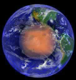
 Cydonia Quest C Image Enhancements C c The First MRO Images of the Cydonia Suburbs Note: This website is best viewed at a screen resolution of 800 x 600 pixels. Higher resolution settings will reduce both the size and quality of the images displayed, thus leading to a loss of detail. For tips on adjusting screen resolution and other ways of improving the screen appearance of the internet click this "stargate" µµµ. c Before analysing the new MRO imagery, it is best to ensure that every reader is completely up to speed about the Cydonia Suburbs. A Briefing about the "Suburbs" for new readers of Cydonia Quest. The "Suburbs" were an unexpected bonus delivered by the higher resolution camera of the Mars Global Surveyor (MGS) spacecraft when it began imaging the enigmatic Cydonia region in 1998. At first glance the "Suburbs" appear to be a dense network of narrow, criss-crossing embankments on the Martian surface. These enclose areas ranging in size between large buildings and city blocks. However, closer examination reveals that the top of the "embankments" are actually at normal ground level and that it is the land between them that has deeply subsided. The pattern of subsidence over some of the Suburbs is noticeably geometrical with rectangular subsidence pits showing purposeful looking arrangements. In MGS imagery these areas very closely resembled a ruined city. This ruined city like appearance is illustrated in the next two pictures. The first shows a section of the Cydonia Suburbs with different areas exhibiting both right angled organisation and more chaotic arrangements of subsidence. The second shows the excavated ruins of the ancient Assyrian city of Assur on Earth. |
| c ccccccccccccccccccccc cccccccccccccccccccccccccccccccc As always with outsized images the reader is advised to use the "View" then "Full Screen" options from the menu bar at the top of their browser screens to see more of the image at the same time. C The Suburbs cover many square miles in the vicinity of the large enigmatic mounds popularised as possible mega-buildings (arcologies) in books such as Richard Hoagland's The Monuments of Mars. The following illustration shows areas where the MGS found particularly extensive Suburbs in relation to these mounds. However, as the MGS's coverage of the areas away from these mounds is very limited it is possible that the Suburb areas shown represent just parts of a single entity. C ccccccccccccccccccccccccc C As for a possible artificial explanation for the suburbs, the Cydonia Quest theory is that they may represent a kind of horizontal arcology. In other words an underground city may have once been tunnelled out below the Cydonia surface. Where the chambers of this underground city have collapsed their geometric shapes and arrangements have been imperfectly transferred to the surface in the appearance of the resulting subsidence pits. Previous Cydonia Quest articles (using MGS imagery) can be read by clicking on the following hyperlinks. In the previous illustration the red area shows the position of the D&M suburbs (see µµµ). The green area shows the "Grill" area (see µµµ & µµµ) and the blue area the "Southern Suburbs" (see µµµ & µµµ). c Analysis of the MRO Images of the Suburbs Let's now proceed with what the new Mars Reconnaissance Observer (MRO) spacecraft reveals about the Suburbs. The MRO recently imaged the western half of the Cydonia City mounds. This new image also captured parts of the Southern Suburbs. The very high resolution of the MRO means that the following analysis can only show examples of Suburbs covering quite small areas. The amount of web space and bandwidth required to show more expansive areas is prohibitive.
|
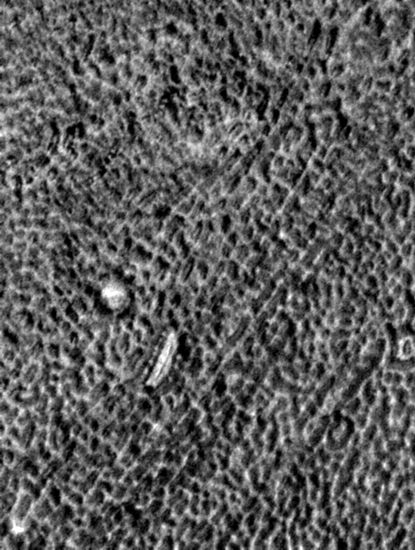

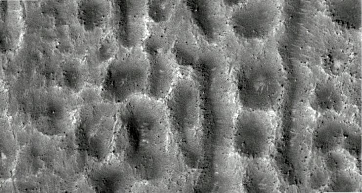
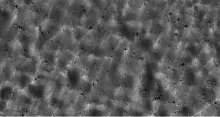
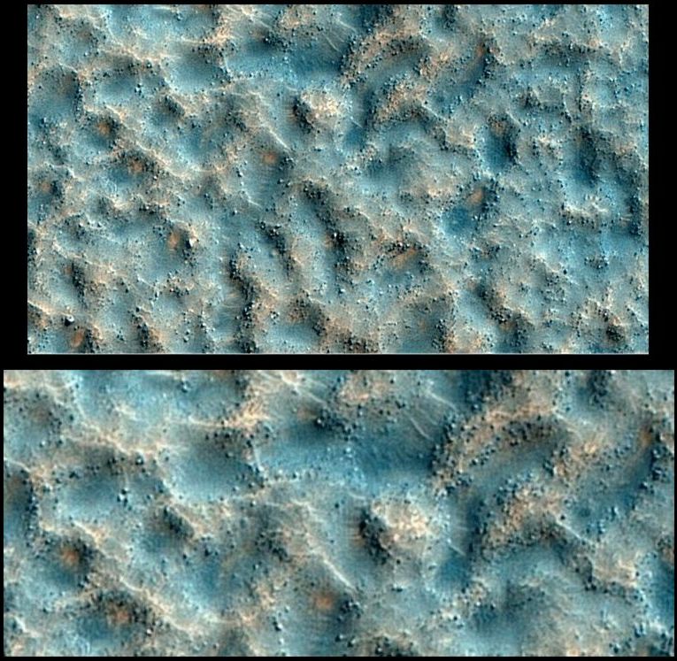
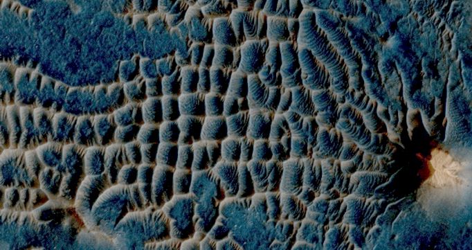
The first example shows an area of Suburbs in which the subsidence pits show some rectangular shape and alignment. Subsidence is most complete in the central parts of the image, whereas to the extreme left and right there are still some fairly level areas. Notice that the partitions between the subsidence pits are rocky in nature. This will be an important consideration later on when exploring possible natural explanations for the Suburbs. C c c The second example is a small area of Suburbs that is actually near the centre of the Cydonia City mounds. This area is on the northern side of the South Mound. (The larger pieces of rubble towards the bottom right of the image have rolled down from the South Mound). It can be seen that these Suburbs have become almost entirely choked by wind blown sand. However, the tops of the jagged partitions between pits are still visible. The effect is very like that of the buried ruins of a city somewhere on Earth. If the reader views this image in a relaxed state of mind then there appears to be organisation and design within this example. C c cccccccccccccccc As always with outsized images the reader is advised to use the "View" then "Full Screen" options from the menu bar at the top of their browser screens to see more of the image at the same time. c The new MRO image reveals that there are also Suburbs to the north of the Cydonia City mounds - only much more deeply buried by drifting sand than the previous example. So the Suburbs are intricately connected with the Cydonian mounds that so intrigued investigators of the artificiality hypothesis back in the 1980's. The next image shows an area to the north east of the Rounded Mound seen in the annotated Viking image above. MRO's high resolution imaging makes it clear what is lurking buried beneath the sands. C c c As well as taking grayscale images like those above, the MRO can also take images over a smaller area within the main image in false colour. In the case of the new image only a small area of "disorganised" Suburbs were captured in false colour. The false colour images are useful in distinguishing between different materials such as sand and rock. The following example shows a section of the "disorganised" Suburbs, which seem to exhibit little sign of possible design. The partitions between the subsidence pits also appear to have suffered considerable erosion in this example. C
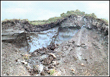
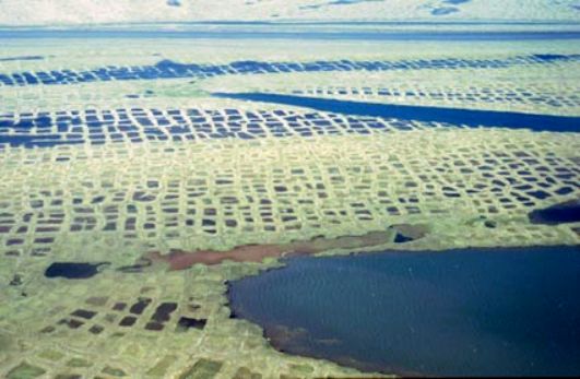
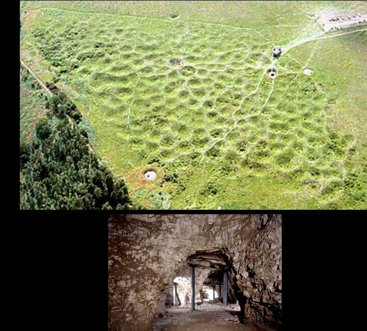
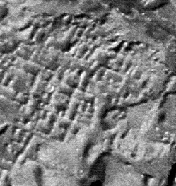
c Exploring Possible Natural Explanations for the Suburbs The fact that the partitions between the subsidence pits of the Suburbs show every sign of being bedrock or some hard artificial material rules out two similar - but natural - looking landscapes as explanations. The Suburbs are not sand dune grids. From earlier, fuzzy imagery of the Suburbs it had been suggested that they were merely sand dune grids. The following example is an MRO image of just such a grid in the poetically named area of Mars known as the Labyrinth of the Night. C cccc C The Suburbs are not ice wedging grids. These grids - usually called ice wedge polygons - form in Arctic permafrost soils. The largest cells in these grids can cover areas as large as seventy feet across. Ice wedging works in the following way. When the permafrost soil is freeze dried it shrinks and cracks. Melt water from heavy seasonal snowfall then fills these cracks and freezes again. Because water expands as it freezes the soil is pushed aside. Every year melt water from new snow continues the process. This has the effect of widening, deepening and lengthening the original cracks in the permafrost. Eventually the landscape is criss-crossed by underground walls of ice. The effect of the widening of the ice wedges is to bulldoze aside the permafrost soil until it is forced up in embankments up to four feet high. The following animated illustration shows a cross section of an ice wedge embankment. C cccccccccccccccccccccccc C As the following aerial photograph shows the effect of these criss-crossing embankments can sometimes be very artificial looking. In this case flooding between the embankments gives the illusion of rice paddy fields. c cccccccccccccc c Ice wedging was never a good explanation for the Suburbs. For a start it is a very long time since Cydonia had the kind of snow fall required to keep ice wedging going. Another objection is that in ice wedging the partitions between polygons are raised up above normal ground level - whereas at Cydonia it is the subsidence of the land that leaves behind the partitions in the Suburbs. The height of the partitions at Cydonia is also of a much greater magnitude than in ice wedging. The MRO images provide an even greater objection. Ice wedging may work in permafrost soil, but is too weak a force to work well on the bedrock seen at Cydonia. Natural subsidence. There are hints in the captions accompanying some MRO images on the internet that MRO team geologists think that the melting of underground ice may be responsible for Martian landscapes similar to the Suburbs. This process can create large subsidence pits in permafrost on Earth. However, there doesn't seem to be anywhere on Earth where such subsidence honeycombs the landscape to the density seen at Cydonia - never mind create geometrical effects. The collapse of caves, old lava tubes and the dissolving of minerals in underground water flows can all cause subsidence in bedrock. However, the author has not been able to find any landscape on Earth where these effects have created a landscape looking like the Suburbs of Cydonia. If there is nothing like the Suburbs on our own planet then this means that (based on orbital imagery alone), any natural model for the creation of the Cydonia Suburbs will remain strictly theoretical - however plausible. If they are completely natural then the complete process for their formation is unique to Mars and would require on the ground investigation to reach the correct explanation. c Does Grimes Graves Provide an Explanation for the Cydonia Suburbs? A Neolithic industrial landscape in Norfolk, known as Grimes Graves, offers a clue to how the Suburbs may have been formed through artificial subsidence. At Grimes Graves Stone Age man dug thirty foot deep mine shafts and lateral tunnels to access a rich seam of flint. Thousands of years later the collapse of these mine shafts and tunnels has created a landscape honeycombed with subsidence pits. The resulting landscape is eerily similar in appearance to the more "disorganised" parts of the Cydonia Suburbs. The example of Grimes Graves does not prove that the Cydonia Suburbs are the result of subsidence from the collapse of an underground city - but this practical demonstration does provide "proof of concept". An artificial explanation for the Suburbs is entirely compatible with the available evidence. As the second photograph shows, archaeologists have now re-excavated some of the ancient tunnels at Grimes Graves. C
c Tips on accessing the MRO data for Cydonia Getting at the MRO imagery on the internet is not as straightforward as it was for the earlier MGS because (a) the best quality images are published in JPEG 2000, which needs special software to view and (b) the MRO image files are too huge for most people's computers to view. For example, the grayscale image that this article is based upon is 801 megabytes. However, there are facilities on the internet that allow the public to zoom into small portions of the master image at full resolution. The first is the IAS viewer that the author used for the analysis in this article. This requires a special bit of software that can be downloaded from the bottom left of this webpage. The IAS viewer has some image enhancement tools that can be applied to MRO images viewed in this way. The grayscale and colour images behind this article can be viewed in either low resolution format or using the IAS viewer on this webpage. Search results for all MRO images of the general Cydonia area can be found here. The second way of viewing MRO imagery is to use NASA Ames Research Centre's Zoomify viewer. I don't think Zoomify produces results to as high a standard as IAS. It is also more difficult to find specific images. However, there are links to compressed versions of the master image around the Zoomify panel that are easier to open up with a PC. For example, there is a nice half sized, compressed version of the false colour image of less than 8 megabytes available here. The Zoomify page for the MRO images used in this article is here. The Zoomify viewer doesn't work properly with the Internet Explorer web browser. It will work with a browser like Firefox that can be downloaded for free from here. µ Back to Part 1 µ Back to Part 2 µ Back to Part 3 C µ Return to the Enhancements page µ Return to the main Mars page
|